Community Corner
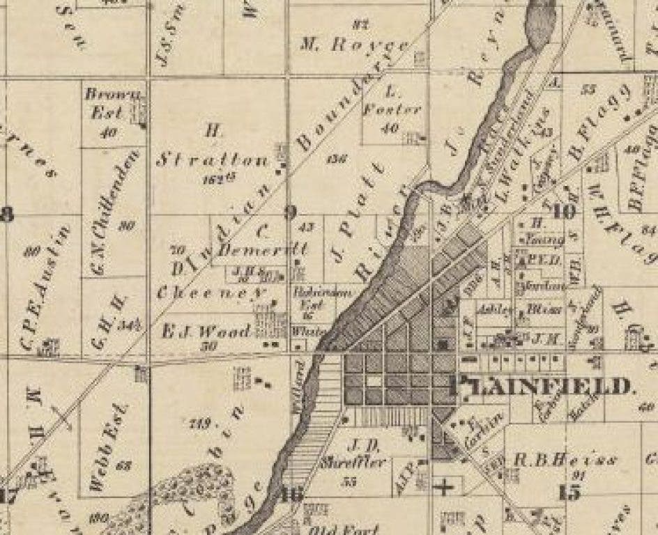
Lambert: Indian Boundary Road Literally Separated Natives from Settlers
The government needed a route that would allow safe passage from Chicago to Ottawa, and negotiated a treaty in the early 1800s that divided Indian land from white settlements.

The Inquiry
What is the significance of Plainfield’s “Indian Boundary Road”?
The Facts
Find out what's happening in Plainfieldwith free, real-time updates from Patch.
This quiet residential street near the western edge of central Plainfield took its name from the events of 200 years ago.
In the early 1800s, improved land and water transportation routes were needed to navigate those “western territories” of the United States that lay east of the Mississippi River. In particular, Americans who traded with the Potawatomie and other Indian tribes wanted to travel freely between the shores of Lake Michigan and the headwaters of the Illinois River at Ottawa.
Find out what's happening in Plainfieldwith free, real-time updates from Patch.
More than a decade before Illinois achieved statehood, Congress considered appropriate transportation improvements within the frontier territory. In 1807, the Senate instructed Secretary of the Treasury Albert Gallatin to report on the subject of potential road and canal routes.
The Gallatin Report identified a low divide between the waters of Lake Michigan and the Des Plaines River that the Indians used as an overland passage. The marshy nature of this overland route at the head of the Des Plaines River had been recorded by the French explorers Joliet and Marquette in 1673 and eventually became known as the Chicago Portage.
Congress was urged to consider the development of a regional canal that would connect Lake Michigan to the Illinois River via the Chicago Portage. However, the War of 1812 postponed all questions of internal improvements.
Separating Indians and Pioneers
The Indian Boundary line came about in 1816, when the Fox and Sauk tribes ceded land to the United States through the Treaty of St. Louis. Before that time, the United States had acquired from the Indians the greater part of what is now Illinois but not the lands adjacent to Lake Michigan, including the Chicago Portage.
The Indian commissioners were instructed to negotiate for a tract of land that would connect the shores of Lake Michigan with the Illinois Purchase.
On Aug. 24, 1816, the United States concluded a treaty with the United Tribes of the Ottawa, Chippewa and Potawatomi. The surrendered area consisted of a 20-mile-wide strip of land, stretching from the shores of Lake Michigan to the Fox River in Ottawa.
The newly negotiated corridor — roughly centered about the Des Plaines River — provided a passage through which white men and women were supposed to be able to travel safely.
Although Illinois achieved statehood in 1818, few pioneers had made any sort of permanent settlement north of the Illinois River.
During the winter of 1818-1819, northern and southern boundary lines were surveyed by John C. Sullivan and his assistant, James M. Duncan. At the time of the first survey, the parties who did the work retrieved supplies from Fort Clark (present-day Peoria).
In the year following the boundary survey, an inspection of the proposed canal route was made by Richard Graham and Joseph Philips, appointed representatives for the Illinois Territory. Their report concluded that a canal route could be constructed for a reasonable expense between the Illinois and Chicago rivers.
Consequently, the land between the two parallel Indian boundary lines was surveyed for canal purposes between 1821 and 1822.
Pioneer Settlement
The land within the “safe passage” corridor was then opened for pre-emption and homestead claims. Pre-emption rights were accorded to those pioneers who settled a tract of land before it had been surveyed and made available for purchase from the federal government. Once the lands were made available, pre-emption rights granted preference to those pioneers.
In 1828, the Walker families and their companions came to the eastern banks of the DuPage River during this early wave of pioneer settlement.
The land beyond the corridor continued to be occupied by Native American tribes. Although, pioneer settlement in northern Illinois was not restricted to the area between the Indian boundary lines, homesteading was much more dangerous outside of the “safe passage” corridor.
In spite of the surveyed lines that established the corridor, natural barriers, such as the DuPage River, provided practical boundaries for settlement and the peaceful co-existence between white settlers and the region’s established Indian communities.
In the immediate area of present-day Plainfield, few white settlers lived west of the river, although the official boundary line was a half mile or more distant to the west.
The Black Hawk War terrified Illinois pioneers between April and September 1832. As a result of the Indian uprising and defeat, all Indian land east of the Mississippi River was ceded to the United States in accordance with the terms of the Chicago Treaty of 1833.
After many years of discussions and appropriations, the Illinois and Michigan Canal was constructed by the state of Illinois between 1836 and 1848.
Vestiges Remain
Today, remnants of the north Indian boundary line remain throughout the western suburbs and within the city of Chicago. Recalling the impact of this once-important survey demarcation, numerous plaques and historical markers have been set at locations along the path.
But at Plainfield, our Indian Boundary Road runs along the actual survey line while, in Chicago, Rogers Avenue (west of Sheridan Road) marks the 194-year-old alignment.